
Rail to Trail Demonstration Ride for National Trails Day on the Perkiomen Trail
Saturday, June 1st, 2013. Penn-Tammany Greenway Coalition Rail to Trail Demonstration Ride for National Trails Day on the Perkiomen Trail.
Meet at the Rahn's Trail head of the Perkiomen Trail at 9:30 AM. There is parking at the trail head which is located off of Route 113 (Bridge Rd.) across the Perkiomen Creek from Central Perkiomen Valley Park. Ready to roll out of the parking lot by 10:00 AM. Ride approximately 4 miles to Pennypacker Mills near Schwenksville which is having a Civil War Reunion that weekend with many scheduled activities including a Civil war medicine demonstration at 11:00 AM and a Civil War Artillery Demonstration at 12:00 PM. Eat lunch at Pennypacker Mills and then return to our cars at the Rahn's trail head by roughly 1:30 PM.
Link to trail map and mileage chart can be found here:
http://www.montcopa.org/index.aspx?NID=1153
Great News for the Pencoyd Trail and Bridge!
The approval process for the Pencoyd Trail and Bridge is moving allow smoothly. On Monday night the Lower Merion Planning Commission gave O'Neill Properties approval for their Tentative Sketch recommendation. Next week O'Neill will appear before the Building and Planning Committee for tentative Sketch approval.
Just to recap: O’Neill Properties plans to develop 569 apartments along the Schuylkill River in Lower Merion. As part of their deal with Lower Merion Township, O'Neill will refurbish the old railway bridge and extend the Pencoyd Trail along their property. The first phase of construction will include construction of an 8’ pedestrian outrigger on the Pencoyd Bridge from Philadelphia to Lower Merion, construction of a .75 mile long, 14’ wide multi-purpose trail along the waterfront, and construction of 2 large public gathering space/plazas at the base of the bridges at either end of the site. The western end of the site will include a 9,000 sq. ft landscaped plaza overlooking Venice island.
O'Neill will also contribute approximately $550,000 as the project is being built, money which will be used to build a connection between his property and the Cynwyd Trail through the Township-owned Connelly property.
This segment is an important connection to the Schuylkill River Trail. It will help facilitate a loop from the Pencoyd Bridge on Main Street (Manayunk) over to Lower Merion Township, up to the Cynwyd Trail, over the Manayunk Bridge and back to Main Street. Congratulations to Lower Merion Township for closing this important trail gap!
PA and NJ Trail Caucus Meetings Coming In June
On behalf of The Circuit Coalition, the Bicycle Coalition of Greater Philadelphia invites you to the launch of the Circuit Commitment Campaign.
We are bringing together trail enthusiasts and supporters like you for two informational sessions in June (one for PA, one for NJ). These caucus meetings are the kickoff to the Circuit Commitment Campaign.
The Circuit Commitment Campaign's goal is to replenish the DVRPC (Delaware Valley Regional Planning Commission)'s Regional Trail Fund, which is a competitive grant program established by the William Penn Foundation in 2010. The fund is distributing nearly $10 million in our nine-county region, and is helping plan, design and build nearly 40 miles of trail.
This grant program, if continued, could have a major impact on our trails! So we need people like you, who want to see The Circuit's unfinished trails built, to encourage County Commissioners (in Pennsylvania) & Freeholders (in New Jersey) to allocate a second $10 million for the years 2014-2016. This money will continue the momentum of that first grant cycle, moving us closer to realizing the vision of a region connected by a world-class network of bike-ped trails: The Circuit.
Get involved in creating new trails for your community by attending your state's trail caucus!
The Pennsylvania Caucus
June 17th, 7:00 - 9:00 PM
Haverford Community, Recreation & Environmental Center
Register to attend here
New Jersey Caucus
June 19th, 7:00 - 9:00 PM
Camden County Boathouse
Register to attend here
The Pennsylvania Caucus meeting will provide an overview of the next set of Circuit trails currently under development in Delaware, Chester, Montgomery, Bucks and Philadelphia Counties.
The New Jersey Caucus meeting will provide an overview of the next set of Circuit trails currently under development in Mercer, Burlington, Camden and Gloucester Counties.
At each meeting, we will also discuss the campaign goal and how you can help get this trail funding secured.
Rails-to-Trails in Middletown (Delco Times/DNN)
Middletown Township businesses get update on Rails to Trails project (DNN)
The Chester Creek Rails-to-Trails project is on track, with construction expected to begin before the end of the year. That was what Mike Fusco of Aston, president of Friends of Chester Creek Branch, told the Middletown Township Business and Professional Association when it met for lunch recently at the Riddle Ale House.
In his PowerPoint update, Fusco presented background information on the non-profit Friends group that was founded in 1997. Run by a volunteer board of directors, its mission is to convert the abandoned Chester Creek branch rail line through parts of Middletown and Aston into a trail. His efforts of more than two decades, and those of the Friends, finally were successful in 2012. That’s when Middletown Council unanimously approved, with some conditions, a land development plan for the project.
That was the necessary first step in a project to convert 2.8 miles of an unused SEPTA rail line, from Creek Road to Lenni Road, into a 10-foot-wide paved trail for walking, jogging and biking (no motorized use) for the community. Aston Council has approved the section traversing its township.
Fusco said it’s taken much longer than anticipated to get the trail underway, noting there are more than 250 pages of plans for the project. He said it’s being developed in three phases. Engineering studies have been completed for the first phase.
“We’re crossing the t’s and dotting the i’s on the final agreements for Phase One,” he said, adding that bids for construction of the initial phase are expected to go out soon and construction should begin later this year.
link to full story:
Middletown OKs signal at Lungren Road (Delco Times)
The Rails-to-Trails project of the Friends of Chester Creek Branch continues to move along, with council’s unanimous approval of the Friends’ application to PennDOT for a pedestrian signal at Lungren Road.
Mike Fusco of Aston, president of the nonprofit Friends group, came before council with Louis Hufnagle of the county planning department to ask for the township’s support of the proposed traffic light.
“The Friends cannot take ownership of the light,” said Fusco. “It has to be a government entity.”
He noted there would be no electricity usage cost to the township, since the flashing light would have a solar-powered motion sensor. However, Middletown would be responsible for maintaining the light, just as with other crossing lights in the township.
link to full story:
http://www.delcotimes.com/articles/2013/05/16/news/doc51944d9f2b62e681454168.txt
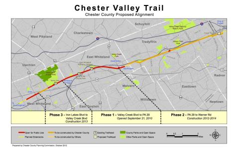
Chester Valley Trail in Tredyffrin ahead of schedule but parking an issue (Main Line Suburban Life)

Tredyffrin residents should be able to walk, jog or cycle their township’s section of the Chester Valley Trail as early as Labor Day.
Construction of Phase 2 of the trail will likely be finished this summer, three months ahead of the November construction deadline, according to Owen Prusack, Chester County Parks Superintendent.
Prusack presented a CVT update to more than 100 people at Wednesday night’s annual meeting of the Open Lands Conservancy of Chester County.
The paved trail is 65 percent finished, he said.
But the picture isn’t totally rosy.
The public will be able to hop on the trail at multiple points but only if they come on foot or bicycle. Those driving to the CVT won’t have it so easy.
“Access isn’t an issue; parking is,” admitted Prusack.
The local section of trail only has two dedicated parking lots – and neither is in Tredyffrin, one at the Warner Road Trailhead in King of Prussia and the other at the Church Farm Trailhead in Exton. (The County plans to double the parking capacity in Exton to 88 spaces by the end of 2013.)
While parks officials have had informal talks with Tredyffrin businesses adjacent to the trail along Swedesford Road, so far none have been willing to allow public trail parking on their lots, Prusack said. The Old Forge Crossing condominium complex has also been approached about providing direct access to the trail, but an agreement has not been reached, he said.
According to Prusack, parks department officials are also working with Tredyffrin Township on the parking issue. Both have decided to take a wait-and-see attitude in the hope that residents will lead the push for more convenient trail parking, he said.
A federal, county and local initiative, the Chester Valley Trail will extend from Exton to the Schuylkill River Trail, making it possible for cyclists to ride into Philadelphia from Tredyffrin and Great Valley. Chester County's portion of the trail roughly parallels Route 30 in its western section and Route 202 in the east. Plans call for the western section of the trail to link Exton to Downingtown.
Outdoor enthusiasts will have to wait a few more years for the CVT to connect to the Schuylkill River Trail however.
Montgomery Township officials are awaiting final engineering studies of the route before construction can begin. Current plans call for the township's section to stretch from S. Warner Road to DeKalb Street in Norristown by way of S. Gulph Road, Henderson Rd., Saulin Boulevard, and DeKalb Pike, said David Clifford, Open Space Planner for the Montgomery County Planning Commission.
"I expect construction to be finished in a year-and-a-half to two years. We're a little behind schedule because of all the dense development in Upper Merion Township, especially around the King of Prussia mall area," he said. With so many office parks clustered in Great Valley Tredyffrin and King of Prussia, both Chester and Montgomery counties expect commuters as well as recreational users to take advantage of the CVT.
A study is also underway to explore ways to link the CVT and the Paoli Train Station, said Molly Duffy, program manager for the Transportation Management Association of Chester County. Such a connection would encourage commuters to cycle or walk to work, thereby easing traffic congestion on Route 30 in Paoli from some 30,000 Great Valley and Vanguard employees, she said.
Chester County's portion of the trail is being built in four stages.
Phase 1 opened in 2010 and runs five miles from the Main Street at Exton shopping complex to the Uptown Worthington development on Route 29 in East Whiteland.
Currently under construction, Phase 2 will extend another seven-and-a-half miles from the Malvern Wegmans at Route 29 to the King of Prussia Wegmans near the Warner Road Trailhead.
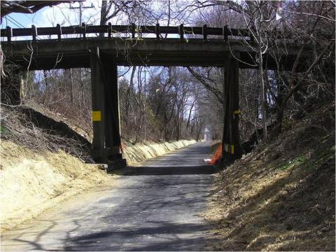
Most but not all of the CVT was constructed over the former Chester Valley Railroad, abandoned since 1993.
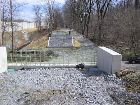
Two of the trail’s pedestrian bridges in Tredyffrin have yet to be built: one at Valley Forge Road and the other at North Valley Road. Construction on both, which will involve road closures over a four-day weekend, will be scheduled between June 15 and July 31 when schools are closed, said Prusack.
The trail will be maintained and patrolled by Chester County park rangers on foot, on bicycle, and on tractor-like “gator” vehicles, also known as XUVs. The County’s emergency, maintenance and patrol vehicles have obtained permission to park at two sites adjacent to the trail: D’Ambrosio Park on Tory Hollow Road in Berwyn and Penn Medicine at Valley Forge near Chesterbrook.
The trail is open to country skiers, cyclists, in-line skaters and the handicapped operating battery-powered wheelchairs. Motorcycles, mopeds, skateboards, snowmobiles and motorized scooters are prohibited.
While the trail remains closed during construction and “No Trespassing” signs are clearly posted, several outdoor enthusiasts at the Open Lands Conservancy meeting admitted to already cycling, jogging and walking their dogs on completed portions.
Residents using the trail before it officially opens should be prepared for park rangers to stop them and “politely explain the situation,” Prusack said.
The public may be impatient to get on the trail, but the project has progressed relatively quickly, especially for an interagency government enterprise, Prusack told the Open Lands crowd. “When you think we took full ownership in 1996 and we will have constructed 12 miles of regional trails by the end of 2013, believe it or not, that’s the speed of light us,” he said.
Middletown Council Unanimously Approves Rails-to-Trails Project (Delco News Network)
the Rails-to-Trails project of the Friends of Chester Creek Branch continues to move along, with council’s unanimous approval of the Friends’ application to PennDOT for a pedestrian signal at Lungren Road.
Mike Fusco of Aston, president of the non-profit Friends group, came before council with Louis Hufnagle of the county Planning Department to ask for the township’s support of the proposed traffic light.
“The Friends cannot take ownership of the light,” said Fusco. “It has to be a government entity.”
He noted there would be no electricity usage cost to the township, since the flashing light would have a solar-powered motion sensor. However, Middletown would be responsible for maintaining the light, just as with other crossing lights in the township.
For more than 17 years, Fusco has pursued the possibility of converting 2.8 miles of an abandoned SEPTA rail line, from Creek Road to Lenni Road in Middletown, into a ten-foot-wide paved trail for public use. The trail will run through part of Aston, which has approved a plan for that portion of the trail.
In January 2012, Middletown Council approved, with some conditions, a land development plan for the project. Fusco had hoped it would get underway this spring, but securing permits has taken longer than anticipated. Council Member Norman Shropshire said that considering all the time that’s been donated to the project, he and his colleagues should do all they can to make the trail a reality.
“Thank you so much for your time and effort,” he said to Fusco, following the vote.
Cynwyd Trail Trot (Main Line Times)


The Friends of the Cynwyd Heritage Trail held the second annual 5K Run on Saturday and hundreds of runners turned out for the event on a damp cloudy morning.
Awards were given according to six different age groups, including 18 and under, and for the first male and female finishers. Money raised are going to upkeep and maintance of the trail.
Celebrating the Manayunk Fit Fest and Walk The Wall
Representatives of The Circuit will be attending the Manayunk Fit Fest and Walk The Wall all day on Saturday, June 1st.
We will be represented at the Walk The Wall tent in the Levering Street Lot and would love for you and your family to stop by and join us!
So what is Walk The Wall? Challenge yourself to walk the course of the infamous Manayunk Wall that will be tackled by professional cyclists on Sunday, June 2nd during the Philadelphia Cycling Classic! To participate, we ask each person to donate $15 to the BCGP or split your donation amongst the four benefitting Manayunk-Roxborough community organizations!
The event is graciously sponsored by Fairmount Behavioral Health System.
Sign up in advance to “walk The Wall” online here: http://business.manayunk.com/events/details/walk-the-wall-436
Visit Manayunk.com for more details on the event and we’ll see you June 1st!
Signs and Sidewalks on the Delaware River Heritage Trail
Burlington County has nearly completed its first section of the Delaware River Heritage Trail. An on road route along County Road 662 and Farnsworth Ave to the RiverLINE footbridge over Assinpink Creek. The project includes about a mile and half of new sidewalk on both sides of the tiny borough of Fieldsboro connecting with the City of Bordentown.
A new trailhead was completed at Bordentown Beach and signage has been installed. Sharrows modified to reflect the trail logo will be included when the streets are repaved later this year.
Signposts placed at transit stops and landmarks show maps of the trail and provide a historical interpretation of the immediate area. Look for an announcement of a ribbon cutting ceremony for the project in the near future.
Trail Etiquette Banners Arrive on Schuylkill Banks
Just in time for the high season, nine banners with trail etiquette messages were installed today on Schuylkill Banks.
The messages include sharing the path, slowing down and being courteous.
Over 800,000 people use Schuylkill Banks annually and on beautiful warm days, the number of people using the path can make you think you are on I-76 on a Phillies/Eagles game day. User conflicts are not uncommon and The Circuit Coalition decided this was a good place to communicate tastefully some messages about civility and safety.
Many were involved in making these banners possible: the William Penn Foundation, Schuylkill River Development Corporation, Maskar Design, Philadelphia Parks and Recreation, the Narducci Brothers, Delaware Valley Regional Planning Commission and the Bicycle Coalition of Greater Philadelphia.
See you on The Circuit!
Philadelphia Master Plan Comment Period Open
The Philadelphia Trail Master Plan is available for review and public comment until May 31st:
This Master Plan was developed by the Philadelphia City Planning Commission. They plan to adopt the plan at their June or July meeting.
Gloucester & Camden Residents: Speak up for Rail-With-Trail (NJ.COM))
By Denise Copeland/Betty the Bike
Residents of Gloucester and Camden counties interested in the creation of new outdoor recreational opportunities are being encouraged by the Circuit Coalition to attend a public information meeting on Monday, May 20, 2013.
The Glassboro-Camden Line Project Team will hold the meeting from 6:00 pm to 8:00 pm at the Woodbury Jr/Sr High School located at 25 North Broad Street, Woodbury.
The GCL corridor traverses Gloucester and Camden counties and includes the communities of Glassboro, Pitman, Sewell, Mantua Twp., Deptford Twp. Wenonah, Woodbury Heights, Woodbury, Westville, Brooklawn, Gloucester City, and Camden. The proposed line would restore passenger rail service along an existing rail line using light rail vehicles similar to the NJ TRANSIT River Line.
The Circuit Coalition is advocating for the inclusion of a multi-use trail along the corridor. The trail option was not included in the initial scoping of the project was not considered. Since this project is still in the early stages there is still time to study the possibility of a rail with trail.
A working example of an existing multi-use rail-with-trail in New Jersey is the Traction Line in Morris County. The Traction Line Recreation Trail is popular for biking, jogging, cross country skiing, walking and strollers, and runs along the New Jersey Transit Line between Morristown and Madison.
The purpose of the public meeting is to review the outcome of the original public scoping meetings which were held by the Glassboro-Camden Line Team in the spring of 2010. The meeting will have no formal program, and attendees may arrive at any time during the meeting hours to view project display boards.
Anyone who is interested in a multi-use trail between Camden and Glassboro should attend this meeting and speak in favor of a rail with trail option.
For more details about the project go to http://www.glassborocamdenline.com/
Comment On The 2014 NJ TIP
The TIP or Transportation Improvement Program is a regional priority list of federally funded transportation projects that are in the development pipeline. Metropolitan Planning Organizations are required to compile the TIP by law and must allow the public to comment.
The Delaware Valley Planning Commission has opened open up its Draft 2014 NJ Transportation Improvement Program for public comment. Concurrently DVRPC is accepting comments for the NJDOT 2014 State Transportation Improvement Program(STIP) which is more commonly known at the Capital Program.
A public meeting and information session will be held: WEDNESDAY, JUNE 12, 2013 4:00 p.m.–6:00 p.m.
Cherry Hill Free Public Library
1100 Kings Highway North
Cherry Hill, NJ 08034-1970
In addtion to the commenting via the mapping tool, DVRPC encourages the public to submit comments on the Draft TIP by email to ; After consideration of the public comments, the DVRPC Board may adopt the Draft TIP with any recommended changes at the July 25, 2013 Board meeting.
The TIP is an excellent opportunity to ask DVRPC, the NJ Counties and NJDOT to replenish the Regional Trails Fund. When you explore the map you may notice that there is only one Circuit project on the TIP (in Gloucester County). Finally NJDOT is still trying to figure out what to do with a $40 million of unobligated Transportation Enhancements funds, encourage them to spend it on trail projects before the Feds take it all back.
On the positive side NJ DOT saved the Safe Routes to Schools programs by using Highway Safety Funds to pay for the program (Congress took away the money in MAP-21). If you do send comments don't forget to thank them for that important accomplishment.
58th Street Greenway Preview
With the ribbon cutting for the 58th Street Greenway only 3 weeks away, we decided to take a sneak peak of the route.
Gloucester Camden Line Meeting - What About Rail With Trail?
The Glassboro-Camden Line Project Team will hold a public informational meeting on Monday, May 20, 2013 at the Woodbury Jr/Sr High School located at 25 North Broad Street, Woodbury, NJ 08096 from 6 to 8PM. The purpose of the public meeting is to review the outcome of the public scoping meetings which were held by the Glassboro-Camden Line Team in the Spring of 2010. The meeting will have no formal program, and attendees may arrive at any time during the meeting hours to view project display boards.
The Hiawatha Rail Line (Blue Line) opened in Minneapolis in 2004 with an adjacent rail trail.
SRT's Most Critical Gap Comes into Focus
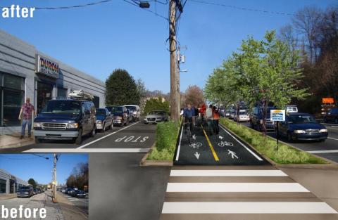
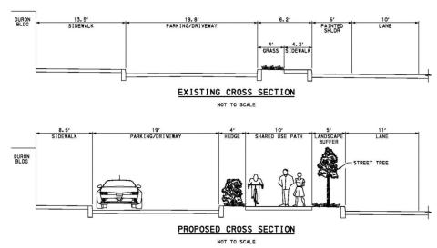
The most critical gap in the Schuylkill River Trail within Philadelphia is the Wissahickon Gateway. It's the name for a section of the trail that must thread its way in between and around a complicated set of parcels owned by multiple owners that lie in between Kelly Drive and the Penncoyd Bridge on Main Street, a distance of about 1 mile.
Currently, most recreational riders bicycling from Center City turn around where the path on Kelly Drive ends at Ridge Avenue. Beyond that corner is an inhospitable set of barriers that deter a signficiant portion of riders who might otherwise be willing to ride further. These barriers include a narrow sidewalk along Ridge Avenue over the Wissahickon Creek, a SEPTA transportation center with many people standing on the sidewalk waiting for buses, constant movement of bus, truck and motor vehicle traffic going inbound and in and out of driveways along Ridge Avenue. The area is considered one of the City's most dangerous intersections for crashes.
This section of the SRT has befuddled many for years and closing the gap has been slow going. But, finally, it is beginning to come into focus. In 2010, Philadelphia Parks and Recreation (PPR) won a DCNR grant to conduct an engineering study. They hired Michael Baker Jr. Inc to conduct a "preliminary" engineering study of the area. It was the first study since a conceptual plan was conducted by the Schuylkill Project in 2008. A stakeholder committee was established and met three times with the consultants and PPR staff. One public meetings was held on November 1, 2012.
Essentially, three alignments were evaluated. In each case, a new bridge crossing over the Wissahickon Creek is required.
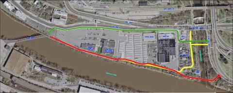
The Michael Baker 2013 study and appendices detail the advantages and challenges of each of the three alignments. Alternative #3 has the challenge of weaving in between the SEPTA bus transportation center and the PECO site. Alternative #2 was met with considerable resistence from both the Canoe Club and PECO. Alternative #2 and #1 also has considerable physical obstructions that would require building a boardwalk. The owner of the parcels and buildings that housed the old Duron paint store, Restaurant Depot and Mr. Store-It was approached to see if they would allow their land to be acquired or go into an easement for either the #2 alignment, but the owner, the Steinberg family (MBS Associates), rejected that consideration.
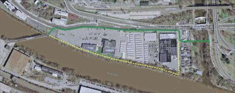
As of Spring 2013, PPR has settled on a separate short term (green) and long term (dashed yellow) alignments (see below). Once it works out agreements with SETPA and PECO to move their fence lines, it will go foward with designing the green alignment. In the future, when the Steinberg family decides to sell its parcels, the City will attempt to implement the long term alignment (in dashed yellow). The short term alignment is estimated to cost around $2.5 million.
Connecting Gloucester Trails and Complete Streets Workshop
Connecting Gloucester
Trails, Bike/Pedestrian and Complete Streets for Gloucester County Communities
Saturday, May 11
114 Bridgeton Pike
Mullica Hill, NJ
-
the basics of bike/ped/trails planning at the municipal level, including a case study of
how Harrison Township developed its new bike/ped plan; - existing grant programs and resources towns can tap to help with their plans and implementation;
- a status report on The Circuit, the Delaware Valley's 750-mile regional trail network, and how Gloucester and other south Jersey counties are participating; and
- how local bike/ped plans and complete streets programs can support regional plans in Gloucester County and beyond.
Registration:
If your commission is on the ANJEC Workshop Plan there is no charge to attend.
To register and for further information, or call 973-539-7547.
Connecting The Circuit Update (Plan Philly)
CONNECTING THE CIRCUIT
By Christine Fisher, Plan Philly
Just as Philadelphia is looking to expand its own trail network, The Circuit, a coalition of regional leaders, is working to strengthen and expand the network of trails throughout the Greater Philadelphia region.
In a sum of the parts is greater than the whole scenario, Philadelphia’s trails stand to benefit from being part of The Circuit, a larger, interconnected, regional trail network, said Chris Linn, senior environmental planner at the Delaware Valley Regional Planning Commission. As in Philadelphia, the region’s trails provide outdoor green space, connect neighborhoods and continue to be the number one recreation facility desired by city residents.
Linn and other Circuit leaders hope to grow the network by 450 miles. This is in addition to the 250 miles already completed and the 50 miles currently under construction. The estimated cost of those 450 miles - $250 million or $12.5 million over 20 years – drew a quiet but audible gasp from Pedestrian and Bicycle Summit attendees.
When complete the network will boast 750-miles of connected trails. The Circuit will tie into other, even larger networks like the East Coast Greenway, a continuous greenway from Maine to Florida that is currently being development.
As Philadelphia continues to expand its on and off road bicycle and recreation facilities, Linn said he hopes groups building just a mile or two of trail or bike infrastructure will start to realize that they are part of a larger effort.
Philadelphia's Trail Master Plan Prioritizes 105 trail miles (Plan Philly)
By Christine Fisher in Plan Philly
May 2, 2013. A new plan guiding Philadelphia’s bike and recreation trail expansion could be in place as early as this June. That's when the Philadelphia City Planning Commission (PCPC) will likely vote on adopting the Philadelphia Trails Master Plan.
Like the Philadelphia Pedestrian and Bicycle Plan, which now guides road-facility changes, the Philadelphia Trails Master Plan will guide off-road trail developments. It will also prioritize the construction of proposed trails.
At the Greater Philadelphia Pedestrian and Bicycle Summit early this week, Jeannette Brugger of PCPC shed some light on the plan.
The Trails Master Plan proposes the city add 75 trails, roughly 105 trail miles, to the existing network of more than 200 miles of trails. Today the existing trails are comprised of 150 miles of soft surfaces and 60 miles of hard, “bikeable” surfaces. Most of the existing and proposed miles are on Parks and Recreation Department land.
In draft form, the Philadelphia Trails Master Plan prioritizes the proposed trails based on existing commitments, demand, feasibility, connectivity and cost, Brugger said. At the moment 19 miles of trail have first priority. Forty-one miles of trails are listed as second priority, and another 40 miles have third priority ranking.
Brugger said this city-led prioritization of trail development will help to ensure funding is used appropriately and that the city is meetings its trail expansion goals.
Some of the proposed 75 trails are already in the works. Just seven miles of trail are under construction or renovation. Eight-and-a-half miles of trail are in design, and 13.5 miles of trail are in the planning stage.
According to the PCPC blog, the Trails Master Plan will pay close attention to “on-road connectivity and an integrated system.” Among other benefits, this focus is meant to ensure that neighborhoods far “inland” from the trails will be able to access off-road trails via existing or proposed on-road bike facilities.
Brugger said PCPC is developing a Philadelphia Trail Committee with partner organizations who will oversee Trail Master Plan implementation.
Web favorites
- Non Gamstop Casinos
- Casino Not On Gamstop
- Non Gamstop Casinos
- Online Casinos Nederland
- Casinos Not On Gamstop
- Non Gamstop Casino
- UK Casinos Not On Gamstop
- Non Gamstop Casino UK
- Online Casinos
- Non Gamstop Casinos
- Non Gamstop Casinos UK
- オンライン カジノ おすすめ
- Casinos Not On Gamstop
- Non Gamstop Casinos
- Sites Not On Gamstop
- Non Gamstop Casino Sites UK
- Melhores Cassinos Online Com Bônus De Registo
- Casinos Not On Gamstop
- Casinos Not On Gamstop
- Casino Zonder Cruks
- Best Non Gamstop Casino
- Lista Casino Online Non Aams
- Sites Not On Gamstop
- Casino Non Aams
- Bitcoin Casinos
- Meilleur Casino En Ligne France
- Meilleurs Sites De Paris Sportifs Belgique
- Sites De Paris Sportifs Belgique
- Casino En Ligne Belgique
- Casino Non Aams
- Casino En Ligne Fiable
- Nouveau Casino En Ligne
- Casino En Ligne Argent Réel
- Nouveau Casino En Ligne Francais
- Nouveau Casino En Ligne Francais
- Casino Bonus Senza Documenti
- Meilleur Casino En Ligne France
- Meilleur Casino En Ligne
- 꽁머니 토토
- Migliori Siti Casino Non Aams
- Slots Non AAMS
- Casinò Non Aams
- Siti Scommesse Non Aams Affidabile
- Migliori Casinò Online
- Casinò Online Non Aams
- Casino Non Aams
- Casino En Ligne Le Plus Payant