
You are viewing 4 posts with the tag Wissahickon Gateway
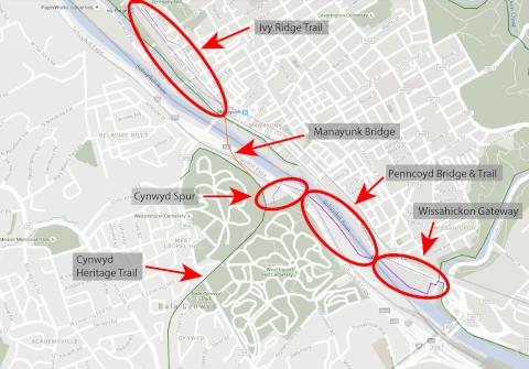
Future Trail Segments Leading to the Manayunk Bridge
In less than a month, the Manayunk Bridge trail will open to great fanfare. This long awaited re-purposing of a SEPTA bridge (originally built by the Pennsylvania Railroad in 1902) is a fantastic achievement and testament to a wonderful collaboration among trail advocates and many agencies, jurisdictions and non-profits, including SEPTA, PennDOT, the City of Philadelphia (Parks and Recreation, Streets and Mayor's Office of Transportation & Utilities), Lower Merion Township Commissioners and Township Planning and Parks staff, Montgomery County Commissioners and Montgomery County Planning Commission, Delaware Valley Regional Planning Commission, and the Circuit Coalition, in particular, the Manayunk Development Corportation and the Bicycle Coalition of Greater Philadelphia. The trail was built with funds dedicated by PennDOT, Pennsylvania Dept of Conservation and Natural Resources, the City of Philadelphia, Montgomery County, Lower Merion Township and the William Penn Foundation. The trail was designed by Whitman Requardt & Associates.
Many people have asked about the status of the various trail segments that lead up to the Manayunk Bridge.
As one can see from the map above, the Manayunk Bridge is on the same rail bed as that of the Cynwyd Heritage Trail on the Lower Merion side, and the Ivy Ridge Trail on the Philadelphia side. It also provides a connection to city streets and Schuylkill River Canal bike path on the Philadelphia side. There are a number of trail segments on both sides of the Schuylkill River that lead to the Manayunk Bridge but gaps do exist. A summary of the status of these various trail segments is below:
The Ivy Ridge Trail lies along the same right of way as the Manayunk Bridge on the old Pennsylvania Railroad inactive rail line. When constructed, it will connect the Manayunk Bridge to the Ivy Ridge SEPTA station parking lot. A feasibility study was conducted by Whitman Requardt & Associates for the City of Philadelphia and Manayunk Development Corporation on this segment in 2014.
The Cynwyd Heritage Trail was completed in 2011 and is owned and maintained by Lower Merion Township.
The Cynwyd Spur is a small section that will connect the Cynwyd Heritage Trail to the Pencoyd Trail and Bridge under construction by O'Neill Properties. This trail has to traverse a steep grade from the Heritage Trail down to the Schuylkill River. Lower Merion Township sought and received funding from DVRPC's Regional Trail Fund and PA DCNR to conduct a feasibility study of this segment. The study is complete and going to be presented to LMT Commissioners in November 2015. Once that presentation is complete, the final copy of the feasibility study will be posted online.
The Pencoyd Bridge and Trail is being developed by O'Neill Properties as part of a residential development project that is currently under construction. Lower Merion Township required O'Neill Properties to rehabilitate the old Pencoyd Bridge and make it publicly accessible to all users (residents and the public). The Township also required that a trail be constructed in front of the development to connect the Pencoyd Bridge to the end of the O'Neill property to its north. The project is expected to be completed by May 2016.
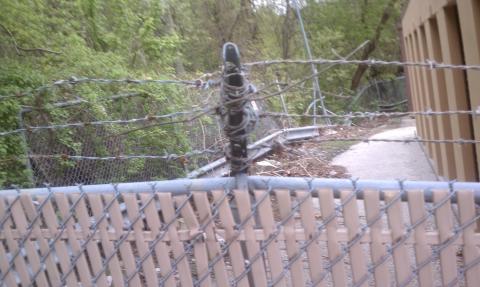
The Wissahickon Gateway is probably one of the most challenging gaps in the Schuylkill River Trail. It was named among the Pennsylvania's top ten trail gaps. The trail segment exists between the East Falls and Manayunk sections of Philadelphia where the Fairmount Bikeway (AKA Schuylkill River Trail) narrows to a sidewalk and terminates on a busy arterial street. Bicyclists wishing to continue east or west along the trail must navigate a narrow bikeway, weave through passengers disembarking and embarking from SEPTA buses, and avoid cars entering and exiting from eleven (11) curb cuts along Ridge Avenue and Main Street. According to trail use statistics, trail advocates have found that while the Montgomery County stretch of trail enjoys 12,500 weekly users and the East Falls section 15,000 weekly users, the area between these two sections only sees 2,500 weekly users. This drop off is directly attributable to the gap at Ridge Avenue and the Wissahickon Creek.
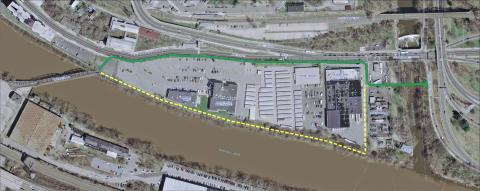
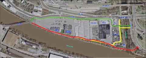
An engineering anaylsis for the Wissahickon Gateway was completed in 2013. The Philadelphia Parks and Recreation Department considered both a "street-side" option (in green) and a "river-front" option (in yellow.) Either alternative requires building a new crossing over the Wissahickon Creek and weaving the trail between a PECO substation and SEPTA bus terminal. The cost of the street-side option is estimated at $2.2-2.5 M for approximately 2000’ of new trail.
SEPTA, PECO and a private property owner own the parcels between the Canoe Club driveway and the Pencoyd Bridge. Once the trail's right of way is obtained by the City of Philadelphia, closing this gap will be the last remaining step in linking 7 miles of trail to the east to Schuylkill Banks and 20 miles west to Phoenixville.
SRT's Most Critical Gap Comes into Focus
The most critical gap in the Schuylkill River Trail within Philadelphia is the Wissahickon Gateway. It's the name for a section of the trail that must thread its way in between and around a complicated set of parcels owned by multiple owners that lie in between Kelly Drive and the Penncoyd Bridge on Main Street, a distance of about 1 mile.
Currently, most recreational riders bicycling from Center City turn around where the path on Kelly Drive ends at Ridge Avenue. Beyond that corner is an inhospitable set of barriers that deter a signficiant portion of riders who might otherwise be willing to ride further. These barriers include a narrow sidewalk along Ridge Avenue over the Wissahickon Creek, a SEPTA transportation center with many people standing on the sidewalk waiting for buses, constant movement of bus, truck and motor vehicle traffic going inbound and in and out of driveways along Ridge Avenue. The area is considered one of the City's most dangerous intersections for crashes.
This section of the SRT has befuddled many for years and closing the gap has been slow going. But, finally, it is beginning to come into focus. In 2010, Philadelphia Parks and Recreation (PPR) won a DCNR grant to conduct an engineering study. They hired Michael Baker Jr. Inc to conduct a "preliminary" engineering study of the area. It was the first study since a conceptual plan was conducted by the Schuylkill Project in 2008. A stakeholder committee was established and met three times with the consultants and PPR staff. One public meetings was held on November 1, 2012.
Essentially, three alignments were evaluated. In each case, a new bridge crossing over the Wissahickon Creek is required.
The Michael Baker 2013 study and appendices detail the advantages and challenges of each of the three alignments. Alternative #3 has the challenge of weaving in between the SEPTA bus transportation center and the PECO site. Alternative #2 was met with considerable resistence from both the Canoe Club and PECO. Alternative #2 and #1 also has considerable physical obstructions that would require building a boardwalk. The owner of the parcels and buildings that housed the old Duron paint store, Restaurant Depot and Mr. Store-It was approached to see if they would allow their land to be acquired or go into an easement for either the #2 alignment, but the owner, the Steinberg family (MBS Associates), rejected that consideration.
As of Spring 2013, PPR has settled on a separate short term (green) and long term (dashed yellow) alignments (see below). Once it works out agreements with SETPA and PECO to move their fence lines, it will go foward with designing the green alignment. In the future, when the Steinberg family decides to sell its parcels, the City will attempt to implement the long term alignment (in dashed yellow). The short term alignment is estimated to cost around $2.5 million.
Three New Schuylkill River Trail Segments Come into Focus
Over the past few days, Philadelphia's Department of Parks and Recreation (PPR) has unveiled information (and provided one guided tour) about the future of three important gaps in the Schuylkill River Trail.
First, on November 1st, the final results of a preliminary engineering study of the Wissahickon Gateway were presented to the public for the first time at the Gustine Rec. Center. PPR, along with their consultants Baker Inc. and Toole Design, have been negotiating with multiple landowners to figure out a way to thread a trail between East Falls and Manayunk (from the trail on Kelly Drive that ends at Ridge Avenue over to the Pencoyd Bridge on Main Street.)
The main success of this effort has been PECO and SEPTA's agreement to move their fence lines to allow an 8-foot trail to weave its way behind SEPTA's Wissahickon Transportation Center and PECO's substation. By building a new bridge over the Wissahickon Creek and directing trail users behind the bus depot, a significant obstacle in the Schuylkill River Trail will be overcome.
Another property owner involved in the trail planning, the Steinberg family, has not reached an understanding with Parks and Recreation. The Steinberg family owns the Duron Paint Store, Restaurant Depot, and Mr. Storage parcels, and have not agreed to allow a trail behind their buildings. That trail, if allowed, would connect with the existing easement behind Bart Blatstein's Movie Theater and Diner complex.
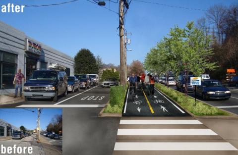
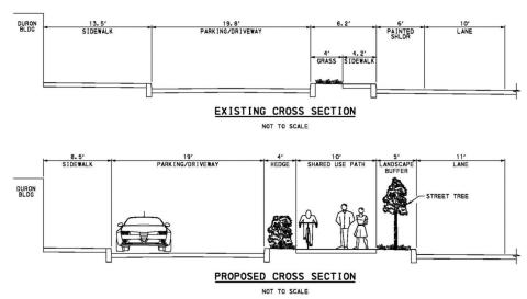
Lacking this section, PPR announced its preference for a sidepath trail along Ridge Avenue and Main Street that will go from the Duron Paint building over to the Pencoyd Bridge. This roadside trail could be constructed by moving the curbline out and using a shoulder that currently exists on the two roads. The downside is that it is next to heavy traffic and crosses seven driveways; the upside is that it is much more feasible in the short term, easier to implement, and less expensive than a riverfront trail. At the public meeting, the Bicycle Coalition of Greater Philadelphia asked PPR to consider it a short term proposal and keep the riverfront option as a long term goal, allowing the possibility that the parcels could be sold and redeveloped in the future. The Bicycle Coalition also asked that the trail be made 12-14 feet wide where possible; a 10-foot path is not wide enough.
The second and third important gaps in the Schuylkill River Trail were made open to the public this past Saturday. This past weekend, Parks and Recreation, PennPraxis, Schuylkill River Development Corp and Bartram's Garden led the first of four civic engagement activities; a bike tour of two parcels lying north and south of Bartram's Garden (Bartram's Mile North and South). Both sites are currently vacant industrial land owned by the Philadelphia Industrial Development Corporation (PIDC). This was the first time that members of the public were allowed to tour these two parcels and they were fascinating! The tour included a visit to a Streets Department Maintenance Facility that lies in between the old National Heat and Power site and Bartram's Garden. The Streets Department facility is the site of a former garbage reduction plant and is a wonderful representative of Philadelphia's hidden industrial history.
Bartram's Mile North includes both the Streets Dept site and the former National Heat and Power site, a brownfield requiring considerable environmental clean up. The parcel ends at 51st and Botanic Avenue, where the Bartram's Garden property begins on the other side of an active freight railway bridge. The National Heat and Power site is a hodgepodge of foundations and retaining walls and was a popular short dumping site until PIDC put up surrounding fencing. A Community Design Collaborative Infill Philadelphia project has already made a proposal on how to develop the land. This site will ultimately connect to the Gray's Ferry Crescent via a new bike/ped Crossing (using an abandoned truss) that is being planned and designed by Schuylkill River Development Corporation.
Bartram's Mile South, the former Gypsum/Transmontaigne plant, will start where the end of the Bartram's Garden driveway (next to its Community Farm) where it meets 56th Street and will travel along the river to 58th Street. A connection will be needed to link it to the 58th Street Greenway at 58th and Elmwood St.
Parks and Recreation has been negotiating with PIDC for a frontage of at least 50 feet from the river's edge to create two riverfront trails.
PennPraxis has an online survey seeking input on Bartram's Miles North and South. See below for photos from the recent public discussions and tours of these three upcoming connections of The Circuit. Or send your ideas to
Phila Parks and Rec. To Unveil Concepts for Closing the Most Critical Gap in the SRT
Two years after receiving the funding and lengthy behind-the-scenes negotiations, Phila Parks and Rec. is ready to unveil its current thinking of how to close the Schuylkill River Trails' biggest and most critical gap: the Wissahickon Gateway--the trail segment in between the end of Kelly Drive and Main Street Manayunk.
The public meeting is scheduled for Tuesday, November 1st at 6pm at the Gustine Rec. Center.
For several years in the 2000s, the Schuylkill Project led the effort to close this gap and prepared a Wissahickon Gateway plan with possible alignments. When the Schuylkill Project joined the Complete the Schuylkill River Trail campaign in early 2009, the gap's profile rose and it was highlighted as the most critical gap in the SRT that was hindering greater usage of the trail past East Falls. This gap is particularly tricky because of the need to cross the Wissahickon Creek and weave through multiple properties that are in between the creek on one end and the Penncoyd Bridge on the other. The new attention helped encourage Phila Parks and Recreation to apply for and receive a DCNR planning grant to conduct a preliminary engineering study in late 2009. In 2010, PPR hired Baker and Associates to conduct the study and they focused on two alignments; one along the riverfront and one along the Ridge Ave/Main St sidewalk.
The study was kicked of in early 2011. After eighteen months of negotations with the Philadelphia Canoe Club, SEPTA, PECO and the Steinberg family who owns the former MAB paint store, restaurant depot and Mr. Storage, PPR is ready to share with the public their concept of how to align a new bridge and trail and close the gap.
Below are two renderings provided by Parks and Recreation and two photos of existing conditions. They represent one trail option under consideration by Parks and Recreation.
Web favorites
- Non Gamstop Casinos
- Casino Not On Gamstop
- Non Gamstop Casinos
- Online Casinos Nederland
- Casinos Not On Gamstop
- Non Gamstop Casino
- UK Casinos Not On Gamstop
- Non Gamstop Casino UK
- Online Casinos
- Non Gamstop Casinos
- Non Gamstop Casinos UK
- オンライン カジノ おすすめ
- Casinos Not On Gamstop
- Non Gamstop Casinos
- Sites Not On Gamstop
- Non Gamstop Casino Sites UK
- Melhores Cassinos Online Com Bônus De Registo
- Casinos Not On Gamstop
- Casinos Not On Gamstop
- Casino Zonder Cruks
- Best Non Gamstop Casino
- Lista Casino Online Non Aams
- Sites Not On Gamstop
- Casino Non Aams
- Bitcoin Casinos
- Meilleur Casino En Ligne France
- Meilleurs Sites De Paris Sportifs Belgique
- Sites De Paris Sportifs Belgique
- Casino En Ligne Belgique
- Casino Non Aams
- Casino En Ligne Fiable
- Nouveau Casino En Ligne
- Casino En Ligne Argent Réel
- Nouveau Casino En Ligne Francais
- Nouveau Casino En Ligne Francais
- Casino Bonus Senza Documenti
- Meilleur Casino En Ligne France
- Meilleur Casino En Ligne
- 꽁머니 토토
- Migliori Siti Casino Non Aams
- Slots Non AAMS
- Casinò Non Aams
- Siti Scommesse Non Aams Affidabile
- Migliori Casinò Online
- Casinò Online Non Aams
- Casino Non Aams