
You are viewing 4 posts with the tag SEPTA
Bridging Gaps High Above the Schuylkill
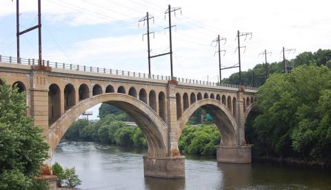
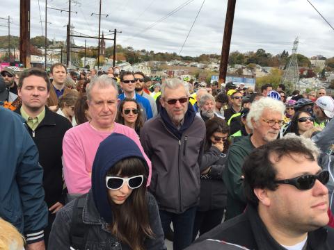
Hundreds of community members, trail advocates and officials convened in the middle of the Manayunk Bridge on Friday to witness a historic moment – the opening of the iconic Manayunk Bridge as a bike-ped bridge.
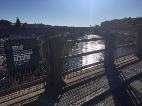
The new 0.6 Manayunk Bridge Trail connects Lower Merion Township and Philadelphia high above the river and the highway, creating a key link in the Circuit Trails that connects the Cynwyd Heritage Trail with Main Street in Manayunk and the Schuylkill River Trail.
When speaking about the first exclusively pedestrian and cyclists bridge over the Schuylkill River, Jorge Brito of the Bicycle Coalition of Greater Philadelphia, said, “the saying ‘never say never’ comes to mind. Projects like this make the city of Philadelphia a landmark.”
Officials, including Mayor Michael Nutter and Elizabeth Rogan gave remarks at the ribbon cutting and reflected on the impact of the project on the region and how it serves as a symbol of the power of collaboration. Mayor Nutter commented “the $5.76 million project revitalized an almost-forgotten bridge and transformed it into a functioning public space that expands and encourages recreational use.”
The story of the Manayunk Bridge Trail is a story of willpower and collaboration. To really appreciate this historic day, one needs to know how we got to this point:
1918 – Manayunk Bridge was built by the Schuylkill Valley Division of Pennsylvania Railroad.
1976 – Bridge was acquired by SEPTA.
1986 – Bridge was closed due to low ridership on the Ivy Ridge Line.
2008-2010 – SEPTA removed the tracks on rail bed and community groups held clean ups, to raise public awareness about restoring the rail line.
Commissioners of Lower Merion Township leased the rail bed from SEPTA and raised the funds to construct the Cynwyd Heritage Trail, which opened in late October 2011.
2008-2009 – The Manayunk Bridge became one of the nine identified gaps in the Complete the Trail campaign that the Bicycle Coalition of Greater Philadelphia launched with the Manayunk Development Corporation and other organizations.
2010 – The bridge was included in a large proposal written for six counties by the Coalition and Pennsylvania Environmental Council that was submitted to the U.S. Department of Transportation for a grant to build 17 trail segments.
The William Penn Foundation and Pennsylvania’s Department of Conservation and Natural Resources (DCNR) awarded grants to the Manayunk Development Corporation to conduct a feasibility study of the Manayunk Bridge and Ivy Ridge Trail. These two grants brought all of the stakeholders together to make the project possible.
Late 2010 – The Mayor’s Office of Transportation and Utilities applied for a $1.3 million grant from PennDOT’s Pennsylvania Community and Transportation Initiative for the Bridge, allowing consultants to start designing the bridge trail.
October 25, 2011 – Official opening of Lower Merion Township’s adjacent Cynwyd Heritage Trail.
October 28, 2014 – Officials and residents gathered for the groundbreaking of the Manayunk Bridge Trail.
October 30, 2015 – Opening of the Manayunk Bridge.
The project, which broke ground last fall, is a visible reminder of the power of a strong vision and collaboration. As Elizabeth Rogan said, “the achievement is a testament to the leadership of individuals and the power of partnership.”
Alas, one more critical piece of the Circuit puzzle is complete, with 450 miles to go to reach 750 miles of interconnected trails in the nine-county region. The next bike-ped bridge over the Schuylkill will not be far behind.
Barry Seymour, executive director of the Delaware Valley Reginal Planning Commission, put it best when he said the bridge will make us “healthy, wealthy and wise.” So, get out #onthecircuit and use the trail!
For the best route to bicycle to the Manayunk Bridge Trail, explore the Google Map here
DVRPC Shares Data, Revealing Which Philly Streets Cyclists Use Most
CyclePhilly – an app produced by Code for Philly, the Bicycle Coalition of Greater Philadelphia, DVRPC, Septa and the City of Philadelphia – logs voluntarily-shared cyclist trip data. DVRPC recently released six months of that data, revealing which routes cyclists like best. The data was gathered from 220 unique CyclePhilly users and 8,340 individual trips.
Some highlights include:
| Activity | Number of Trips | Top Philly Street |
| Total Trips | 866 | Spring Garden, between 9th & 10th |
| Commuting | 672 | Spring Garden, between 6th & 7th |
| Doing Errands | 68 | Pine, between 15th & 17th |
| Exercise | 65 | Schuylkill River Trail, between Art Museum & 25th |
| Social | 99 | Spring Garden, between 9th & 10th |
Read the full article on Plan Philly here to learn more about the app and what’s in store for the future of biking in Philadelphia: http://planphilly.com/articles/2015/05/06/dvrpc-releases-new-cyclephilly-data-on-which-streets-cyclists-use-most
Pennypack Trail Extensions Improve Access to Regional Rail
Before yesterday's opening of the north and south extensions of the Pennypack Trail in Montgomery County it was very difficult to get to or from the trail via SEPTA. The only trailhead was almost in the dead center of the trail on the narrow and twisty Moredon Rd in Lorimer Park. It wasn't impossible, you could get could get close via the 24 or 88 bus but the on road distance and difficulty to get to the faster and more direct regional rail trains didn't make the trip worthwhile.
The new section up to Welsh Road is now linked to the Bethayres Station on the West Trenton Line via a sidewalk that begins at the bridge over Pennypack Creek. Biking on Huntingdon Pike and Welsh Road requires a tolerance for riding in fast traffic without shoulders.
From the Bethayres station:
- Follow the sidewalk at the north end of the station lot up to the signal at Chestnut St
- Cross Huntingdon Pike and turn right to follow the narrow sidewalk
- Continue on the sidewalk around the Bethayres Market along Welsh Rd
- The sidewalk ends at the bridge near the trailhead.
- DIstance is 3/4 of a mile or a 15 minute walk
The new bridge at the south end of the trail crosses a deep ravine and Shady Lane and eases the trip from Fox Chase Station on the Fox Chase Line. The on road bike route from Fox Chase is less stressful than from Bethayres but there are also sidewalks for pedestrians.
From the Fox Chase station:
- Head north to the Rhawn St exit
- turn left then right at the Oxford Ave/Pine Rd intersection if you are walking cross the Rhawn St here
- Turn right onto Huntingdon Pike (to the left of Dunkin Donuts) for two blocks and turn right on Blake Ave
- Blake Avenue bends left and becomes Rockledge Ave
- Turn right onto the trail at Rockledge Park
- Distance is 8/10 of a mile or 15-20 minute walk
Bus Bridging the Schuylkill River Trail
The Berks Area Transportation Authority (BARTA) has just announced that their entire bus fleet is now bike rack equipped. So while the dream of bicycling or walking off road from Philadelphia to Pottsville is still several years in the future it is now possible to experience most of the existing Schuylkill RIver trail without dealing with complicated and hilly road routes.
The two largest gaps in the trail network are parallel to bike rack equipped commuter bus routes. In Montgomery County County take the Schuylkill River Trail/Perkiomen Trail to Collegeville where you can catch SEPTA Route 93 westbound at the Main St crossing. The bus will take you to the Pottstown to Reading portion of the Schuylkill River Trail. When you get to Downtown Reading BARTA bus 20 will take you to the John Bartram Trail section in Hamburg. From Hamburg you can travel another 7 miles to the current terminus of the trail at Pine Lane in South Manheim Township near Auburn in Schuylkill County.
If you are starting your bike trip in Philadelphia allow two long days or three easy days for the round trip. Camping and lodging accommodations are located in or near Reading, Hamburg and Auburn.
Schuylkill River/Perkiomen Trail - Philadelphia to Collegeville
SEPTA Route 93 on Google Transit - Collegeville to Pottstown
Schuylkill River/Thun Trail - Pottstown to Reading
BARTA Route 20 Schedule (pdf) - Reading to Hamburg/Hamburg to Reading
John Bartram Trail- Hamburg to Pine Lane
Transit Details:
- The Route 93 bus connects at Norristown Transportation Center for SEPTA Regional Rail and High Speed Line Service to Philadelphia.
- Route 20 bus does not run on Sundays.
- BARTA Bus Terminal is at 5th and Penn St in Reading
- One Way Fares (Exact Change) Route 93 $2.00, Route 20 $2.05
- Bike on Bus Instructional Video