SRT's Most Critical Gap Comes into Focus
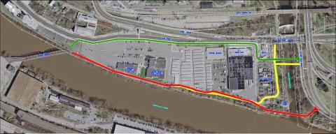
The most critical gap in the Schuylkill River Trail within Philadelphia is the Wissahickon Gateway. It's the name for a section of the trail that must thread its way in between and around a complicated set of parcels owned by multiple owners that lie in between Kelly Drive and the Penncoyd Bridge on Main Street, a distance of about 1 mile.
Currently, most recreational riders bicycling from Center City turn around where the path on Kelly Drive ends at Ridge Avenue. Beyond that corner is an inhospitable set of barriers that deter a signficiant portion of riders who might otherwise be willing to ride further. These barriers include a narrow sidewalk along Ridge Avenue over the Wissahickon Creek, a SEPTA transportation center with many people standing on the sidewalk waiting for buses, constant movement of bus, truck and motor vehicle traffic going inbound and in and out of driveways along Ridge Avenue. The area is considered one of the City's most dangerous intersections for crashes.
This section of the SRT has befuddled many for years and closing the gap has been slow going. But, finally, it is beginning to come into focus. In 2010, Philadelphia Parks and Recreation (PPR) won a DCNR grant to conduct an engineering study. They hired Michael Baker Jr. Inc to conduct a "preliminary" engineering study of the area. It was the first study since a conceptual plan was conducted by the Schuylkill Project in 2008. A stakeholder committee was established and met three times with the consultants and PPR staff. One public meetings was held on November 1, 2012.
Essentially, three alignments were evaluated. In each case, a new bridge crossing over the Wissahickon Creek is required.
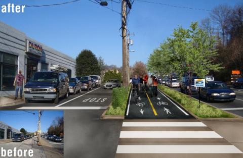
The Michael Baker 2013 study and appendices detail the advantages and challenges of each of the three alignments. Alternative #3 has the challenge of weaving in between the SEPTA bus transportation center and the PECO site. Alternative #2 was met with considerable resistence from both the Canoe Club and PECO. Alternative #2 and #1 also has considerable physical obstructions that would require building a boardwalk. The owner of the parcels and buildings that housed the old Duron paint store, Restaurant Depot and Mr. Store-It was approached to see if they would allow their land to be acquired or go into an easement for either the #2 alignment, but the owner, the Steinberg family (MBS Associates), rejected that consideration.
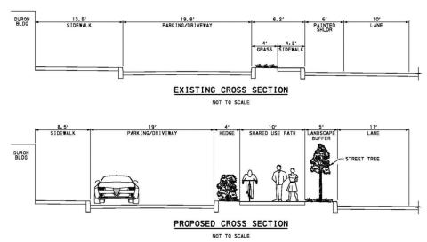
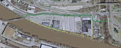
As of Spring 2013, PPR has settled on a separate short term (green) and long term (dashed yellow) alignments (see below). Once it works out agreements with SETPA and PECO to move their fence lines, it will go foward with designing the green alignment. In the future, when the Steinberg family decides to sell its parcels, the City will attempt to implement the long term alignment (in dashed yellow). The short term alignment is estimated to cost around $2.5 million.
Web favorites
- Non Gamstop Casinos
- Casino Not On Gamstop
- Non Gamstop Casinos
- Online Casinos Nederland
- Casinos Not On Gamstop
- Non Gamstop Casino
- UK Casinos Not On Gamstop
- Non Gamstop Casino UK
- Online Casinos
- Non Gamstop Casinos
- Non Gamstop Casinos UK
- オンライン カジノ おすすめ
- Casinos Not On Gamstop
- Non Gamstop Casinos
- Sites Not On Gamstop
- Non Gamstop Casino Sites UK
- Melhores Cassinos Online Com Bônus De Registo
- Casinos Not On Gamstop
- Casinos Not On Gamstop
- Casino Zonder Cruks
- Best Non Gamstop Casino
- Lista Casino Online Non Aams
- Sites Not On Gamstop
- Casino Non Aams
- Bitcoin Casinos
- Meilleur Casino En Ligne France
- Meilleurs Sites De Paris Sportifs Belgique
- Sites De Paris Sportifs Belgique
- Casino En Ligne Belgique
- Casino Non Aams
- Casino En Ligne Fiable
- Nouveau Casino En Ligne
- Casino En Ligne Argent Réel
- Nouveau Casino En Ligne Francais
- Casino Bonus Senza Documenti
- Meilleur Casino En Ligne France
- Meilleur Casino En Ligne
- 꽁머니 토토
- Migliori Siti Casino Non Aams
- Slots Non AAMS
- Migliori Casinò Online
- Casinò Online Non Aams