You are viewing 73 posts by the author John Boyle
Go Philly Go - Directions for Multimodal Trips
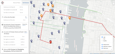
Over the past 10 years it has become a lot easier to to obtain bike, walk or transit travel information thanks to a plethora of web and phone applications such as Google Maps, The Transit App and Ride the City. However where those applications fall short is when you need multimodal directions. A common scenario is that you get off the Market Frankford El but your next connecting bus is in a half hour. And then when you reach your stop, you then have to walk 5 blocks to your final destination.
Enter GoPhllyGo.
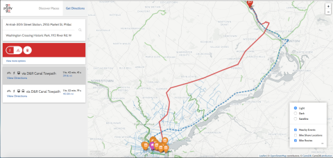
GoPhillyGo essentially takes Google Directions to the next level. The app not only allows you to get multimodal directions with own bike, but you can also find out if Indego bike share is available for your trip. Or maybe you just want to find great places to go. GoPhillyGo includes completed Circuit trails and can produce a coverage map for up to 2 hours of travel time.
DVRPC Announces CMAQ Competive Funding For South Jersey
The Delaware Valley Regional Planning Commission is now accepting applications for Congestion Mitigation Air Quality (CMAQ) projects in Burlington, Camden, Gloucester and Mercer Counties. Bicycle and Pedestrian projects such as trails are eligible for CMAQ funds.
DVRPC will be accepting CMAQ Program applications from January 9, 2015 until 5:00 P.M. on Thursday, April 9, 2015. A mandatory information session for applicants will be held at 4:00 P.M. on January 28, 2015 in the DVRPC Conference Room, 190 N. Independence Mall West, 8th Fl., Philadelphia, PA 19106.
For more details on program guidance as well as submitting an application visit the DVRPC CMAQ web page.
Upper Merion Breaks Ground on Schuylkill River West Trail
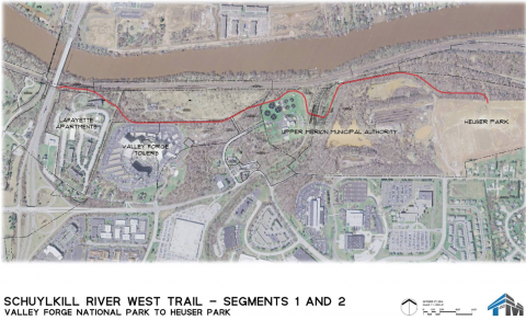
In what we can honestly say is the final trail groundbreaking of the year, Upper Merion Township officials held a ceremony on December 11th in Heuser Park for the first segment on the Schuylkill River West Trail. Hueser Park is located at the foot of Geerdes Boulevard only a few blocks downhill from PennDOT's District 6-0 offices.
The trail will span 2.2 miles from Heuser Park to Valley Forge NHP at an existing trail underpass at Route 422 near the future Sullivan's Bridge. The vision for the Schuyllkill River West Trail will run all the way to Martin Luther King Drive in Philadelphia creating a 30 mile loop, however at this time the trail is only conceptual in Bridgeport, West Conshocken, Lower Merion and Philadelphia.
Pennypack Trail Extensions Improve Access to Regional Rail
Before yesterday's opening of the north and south extensions of the Pennypack Trail in Montgomery County it was very difficult to get to or from the trail via SEPTA. The only trailhead was almost in the dead center of the trail on the narrow and twisty Moredon Rd in Lorimer Park. It wasn't impossible, you could get could get close via the 24 or 88 bus but the on road distance and difficulty to get to the faster and more direct regional rail trains didn't make the trip worthwhile.
The new section up to Welsh Road is now linked to the Bethayres Station on the West Trenton Line via a sidewalk that begins at the bridge over Pennypack Creek. Biking on Huntingdon Pike and Welsh Road requires a tolerance for riding in fast traffic without shoulders.
From the Bethayres station:
- Follow the sidewalk at the north end of the station lot up to the signal at Chestnut St
- Cross Huntingdon Pike and turn right to follow the narrow sidewalk
- Continue on the sidewalk around the Bethayres Market along Welsh Rd
- The sidewalk ends at the bridge near the trailhead.
- DIstance is 3/4 of a mile or a 15 minute walk
The new bridge at the south end of the trail crosses a deep ravine and Shady Lane and eases the trip from Fox Chase Station on the Fox Chase Line. The on road bike route from Fox Chase is less stressful than from Bethayres but there are also sidewalks for pedestrians.
From the Fox Chase station:
- Head north to the Rhawn St exit
- turn left then right at the Oxford Ave/Pine Rd intersection if you are walking cross the Rhawn St here
- Turn right onto Huntingdon Pike (to the left of Dunkin Donuts) for two blocks and turn right on Blake Ave
- Blake Avenue bends left and becomes Rockledge Ave
- Turn right onto the trail at Rockledge Park
- Distance is 8/10 of a mile or 15-20 minute walk
Pennypack Trail Ribbon Cutting Tomorrow
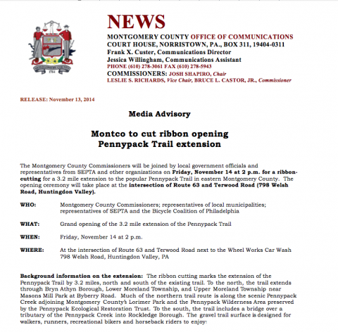
It's been only 5 months since Montgomery County broke ground on the extension of the Pennypack Trail in Huntingdon Valley, where County Commissioner Josh Shapiro declared that "we will open this trail in the fall". Much to our delight the Commissioner kept his promise and so once again we will be at another splended ribbon cutting.
Like the Doylestown Bike Hike event last week the County will be opening two trail segments.
- Huntingdon Pike to Welsh Rd
- A new pedestrian bridge over Shady Lane
Please plan to attend the ribbon cutting Friday November 14th at 2PM in the trailhead parking area at the intersection of Welsh and Terwood Road. Attendees will then either bike or take a shuttle bus to the new pedestrian bridge for a second ribbon cutting.
Doylestown Bike and Hike Cuts The Ribbon on Two Trails
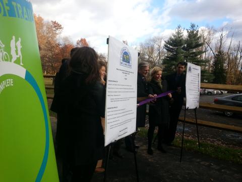
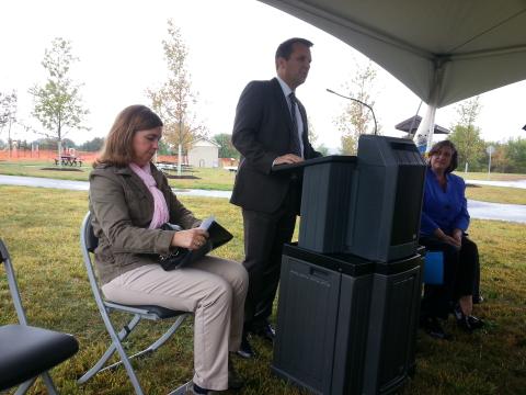
A blustery wind did not deter an enthusiastic group of Bucks County residents and public officials who cut the ribbons on two trails this afternoon in Doylestown Township and New Britain Borough.
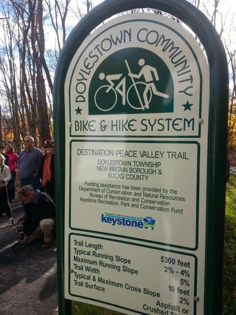
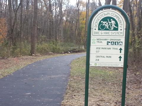
Attendees departed by bus from Covered Bridge Park in New Britain to the newest segment of the Neshaminy Creek Greenway located off Upper State Road in Doylestown Township. The .7 mile trail parallels the creek and connects the 202 Parkway Trail. After the ceremony the group was bused back to Covered Bridge Park for a second dedication for the 1.1 mile long Destination Peace Valley Trail along Pine Run.
Both trails are included in the 24 mile Doylestown Community Bike Hike System. The Bike Hike System is a cooperative project of Doylestown Borough, Doylestown Township, New Britain Borough, New Britain Township and Chalfont Borough.
Chester County Officials Cut the Ribbon on Phase 3 of the CV Trail
The wind and the rain did not dampen spirits at last week's ribbon cutting of of the Chester Valley Trail's phase 3 at Exton Park. County Commissioners, Bike Chester County, DCNR, West Whiteland Township and others were in attendence.
The new segment is only 3/4 mile long. But it connects the main trail to a long orphaned segment that stretches from Main St Exton to Iron Lake Rd and includes a pedestrian activated signalized crossing of Lincoln Highway (Business 30). As a result the trail has expanded to a length of 13 miles between Exton and King Of Prussia.
What makes the Chester Valley Trail so critical is that is in the County's main commercial corridor that is sandwiched between Route 202 and SEPTA's Paoli-Thorndale Line. As a result the trail provides a low stress non-motorized connection between the corridor's office complexes, retail establishments, residential developments and parks.
Chester County now is looking to expand further west. Design work to extend the tail up to the crossing of the Exton Bypass will begin next year. Meanwhile Montgomery County is part way through design for the four mile connection to the Schuylkill River Trail at the Norristown Transportation Center. Construction is expected to start in 2015. The Circuit Coalition will be hosting a walk through the future trail alignment on October 18. Bring your camera to take some before shots so you can brag that you walked it first.
PennDOT Accepting Applications for the 2015-2016 Multi-Modal Fund. But Hurry!
Camden County Parks Widens the Cooper River Trail
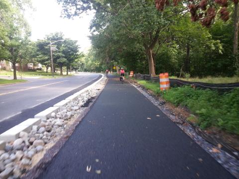
Construction crews are finishing up the widening of the of the Cooper River Trail between Grove St and Colwell Ave in Cherry Hill.
The trail segment which connects Greenwald Memorial Park with Challenge Grove park was poorly marked and maintained. The pathway is now 10 feet wide and completes a walking loop between Haddonfield and Cherry Hill via the Evans Pond Dam and the sidewalk of Kings Highway.
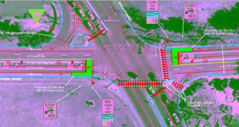
In other news the County has a submitted a Transportation Alternatives proposal for bike lanes on North Park Drive between Route 130 andthe east end of Park Drive near the NJ TRANSIT/Conrail underpass. The proposal as written in the Cooper River Park Safe Access plan includes the first bike lanes in the region with a buffer on the right to prevent dooring. The conceptual plan also proposes for bike boxes at Cuthbert Blvd. Transportation Alternatives funds are competitive so there is no guarantee that money for the bike lanes would be awarded this year.
West of Route 130 a short section of trail funded by the Regional Trails Program is nearing design completion and should go out for bid sometime later this year or perhaps early 2015.
Lehigh Gorge Scenic Railway To Host Bike Train Excursions June 7th and 8th
This weekend (June 7th and 8th) the Lehigh Gorge Scenic Railway in conjunction with Pocono Biking will be hosting bike train excursions between Jim Thorpe and White Haven. Dropping off bicyclists at the White Haven trailhead of the Delaware and Lehigh Trail for a 25 mile rail trail ride back to Jim Thorpe. There will be two departures each day at 10 AM and 2PM. Tickets and bike rentals can be secured with advanced reservation only. For more info go to http://poconobiking.com/trails/train-and-bike/
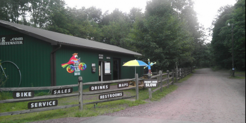
Pocono Biking has also expanded their bike shuttle service to include the Black Diamond and "Appalachian Trail" (Jim Thorpe to Cementon in Lehigh County) sections of the D&L. It is now possible during a weekend stay in Jim Thorpe to explore the entire 60 mile northern section of the D&L in the (slightly) downhill direction without riding out and back.
There are numerous lodgings in Jim Thorpe. Another outfitter in downtown Jim Thorpe, Blue Mountain Sports offers bike rentals and shuttles for the Lehigh Gorge as well as the more challenging Switchback Trail. Finally there is daily direct bus service between Jim Thorpe and Philadelphia via Susquehanna Trailways. You will want to a rent a bike if you choose the bus to avoid the hassle of boxing and unboxing your bike.
Bikes, Food, and Music This Thursday on the Camden Waterfront
The Camden Night Gardens is a free night time art and bike festival on the Camden Waterfront that will take place on Thursday, April 17th from 7:00PM-11:00PM. It will feature local artist performances (music and dance), digital and physically produced projections, site-specific art installations, an illuminated BMX performance, a water-based light production, the presentation of historic record players and recordings, a bike tune-up station and a bike parade.
For the convenience of event goers both the north and south walkways of the Ben Franklin Bridge will be open until midnight. For more information on the Camden Night Gardens visit the event's Facebook Page
The Schuylkill River Trail is Really Closed in Norristown
Update: Montgomery County has announced that the trail will be conditionally opened on the weekends of April 26-27 and May 3-4 (walk bikes through the construction zone). The trail will then be paved and re-open permanently on May 10.
Since January 27 the section of the Schuylkill River Trail between Ross St and Ford Rd in Norristown has been closed due to construction of the Lafayette Street Extension Project. Our assumption was that the trail between those two streets was closed but that access to Ross St from the trail was not affected since the County's trail closure information on their website did not mention that this access point was also severed. However we found out the hard way (from a frustrated trail user) that in fact Ross St was also closed by the construction.
The closure of Ross St entrance changes the alternate routing options dramatically; the nearest access point on the trail, Ernest Station Rd, is about two miles away by road. However, while Ernest Station Rd is not closed to traffic, it is privately owned and therefore the County determined that there was no short and safe on-road detour for the trail.
The trail was scheduled to be reopened later this month, but the unusually harsh winter has set back much of the work. We are awaiting an update from the County on a new target reopening date. Meanwhile if you are determined to ride between Philadelphia and Valley Forge (or beyond) be prepared to take the roads or use the once-per-hour SEPTA Regional Rail service between Conshohocken Station and the Norristown Transportation Center (website). Note that on April 5th and 6th train service between Conshohocken and Norristown will be replaced by bike accessible shuttle buses.
NJ DOT Announces New Round of Transportation Alternatives and Safe Routes to School Funds
Applications are now being accepted for the 2014 Safe Routes to School (SRTS) and Transportation Alternatives (TAP) Programs. The solicitation for these federally funded programs is being administered by the New Jersey Department of Transportation (NJDOT), in partnership with the North Jersey Transportation Planning Authority (NJTPA), the Delaware Valley Regional Planning Commission (DVRPC), and the South Jersey Transportation Planning Organization (SJTPO).
For more information about the SRTS grant, see the solicitation letter here
For more information about the TAP grant, see the solicitation letter here
NJDOT’s application guidance document for the SRTS program containing the necessary information for completing an application and answering questions regarding eligibility and program requirements can be viewed here. The application guidance document for TAP can be viewed here
Applications for both SRTS and TAP are available through NJDOT’s online grant management system, SAGE (System for Administering Grants Electronically). The application deadline is May 15, 2014.
Visit NJDOT’s Local Aid and Economic Development website to learn more about both the SRTS and TAP grants.
Some key things to remember before applying -
NJDOT has heard concerns about Technical Assistance and will be providing more technical support this year. Look for an upcoming webinar, local training/workshops and a tip sheet to improve you application. NJ Safe Routes to School already has developed a TIP sheet for SRTS.
Program managers like to emphasize that both programs distribute funds for reimbursement.
DVRPC has control of about half of the TAP money allocated to the South Jersey counties in its jurisdiction and will be prioritizing these three categories:
- Provisions of facilities for bicycles and pedestrians
- Conversion of abandoned railway corridors to trails
- Stormwater management projects
DVRPC Announces TCDI Planning Grant Funding
On March 5th the Delaware Valley Regional Planning Commission (DVRPC) announced a new competitive round of Transportation and Community Development Initiative (TCDI) planning grants.
- Supporting local planning projects that will lead to more residential, employment or commercial opportunities in areas designated for growth or redevelopment;
- Improving the overall character and quality of life within the region to retain and attract business and residents;
- Enhancing and utilizing the existing transportation infrastructure capacity to reduce demands on the region’s transportation network;
- Reducing congestion by promoting the use of transit and bike and pedestrian transportation modes;
- Building capacity in our older suburbs and neighborhoods;
- Reinforcing and implementing improvements in identified Centers and;
- Protecting our environment through growth management and land preservation
If you municpality or County is interested in applying to TCDI they have to attend a mandatory meeting next Tuesday (March 18th) at DVRPC. The pre-proposal meeting will be held 4pm-6pm, Tuesday, March 18, 2014 at DVRPC Offices, 8th Floor of ACP Building, 190 N. Independence Mall West, Philadelphia, PA 19106. All attendees must RSVP for the meeting to .
A local government official (staff, elected or appointed) must represent the municipality or county. Consultants to the local governments are not considered representatives for this meeting.
To learn more about TCDI go to http://www.dvrpc.org/tcdi/
Supreme Court Ruling on Rail Trails Will Not Affect the Circuit
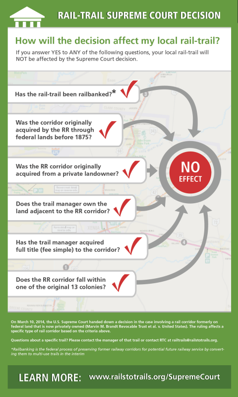
The trail world is abuzz over Monday's Supreme Court ruling in favor of the Wyoming land owners Marvin Brandt Revocable Trust. The ruling awarded ownership of a mile section of the Medicine Bow Rail Trail to the trust, whose land surrounds the trail. The case is considered to be a major blow to rail-trail development and may result in the closing of hundreds of miles of rail trails in Western United States.
While this is a very troubling development for our Western colleagues, the decision will not affect any trails on the Circuit. The Rails-To-Trails Conservancy has created this neat infographic below. The last checkpoint at the bottom should put any local fears to rest.
To find out more about the case go to www.railstotrails.org/supremecourt
Quakertown Area Trails Study Looks At Connecting To The Circuit
The Appalachian Mountain Club (AMC) has released a feasibility study of routing the Pennsylvania Highlands Trail through the Quakertown Area this complements a study released last Spring that analyzed connecting the PA Highlands Trail with the New Jersey segment of the Highlands Trail which is maintained by the NY/NJ Trail Conference.
Like the trail in New Jersey the PA Highlands Trail will be a combination of natural surface trails, rural roads and shared use paths. The Circuit, with a few exceptions only includes the latter, so it is fortunate that most of the trail alignments in the study strived for piecing together new and existing shared use path connections through the region's semi-rural landscape.
The study also breathes new life into the somewhat dormant Liberty Bell Trail alignment which has seen little progress since Mongtomery County published a feasibility study in 2001. Building the trail on the north end has generated a lot of buzz since the popular Saucon Rail Trail was completed to Coopersburg near the Bucks - Lehigh County Line.
The PA Highlands Trail is planned to expand west along Unami Creek to meet the Perkiomen Trail in Northern Montgomery County. Milford Township intends to complete its path network along the creek up to the Montgomery County Line. The Appalachian Mountain Club which is a Circuit Coalition partner is already working on trail planning efforts in Montgomery County.
Quakertown Region Master Trail Plan 2013 uploaded by John Boyle
FHWA Announces TIGER Grant Applications For 2014
The Federal Highway Administration (FHWA) has posted a Notice of Funding Availability for the 2014 TIGER Grant program. Applications will be accepted through Grants.gov for a period beginning on April 3rd 2014 and ending on April 28, 2014.
More information about the 2014 TIGER Program is available at http://www.dot.gov/tiger/nofa
If your eligible organization has not previoiusly registered at Grants.gov before then you need to do so before you apply for TIGER. The registration process takes about 4-6 weeks so you should be start that process immediately. http://www.grants.gov/web/grants/applicants/organization-registration.html
Remembering Mike Fusco - Champion of the Chester Creek Trail
Mike's efforts to create a rail trail go back nearly 20 years. According to the July 1995 edition of the Cyclegram (the Bicycle Coalition's newsletter), Mike and Delaware County Planner Jim Vetterlein began hosting weekly hikes along the Chester Creek Branch. They founded the Friends of the Chester Creek Branch shortly afterward. In 1997 the Friends began cobbling together funds from the William Penn Foundation, Delaware County, DCNR and private contributions in order to conduct a feasibility study which was finally published in 2002.
As President, Mike continued to shepherd the trail development process up to the preparation for construction. The Chester Creek Trail will begin construction this year and the removal of brush and railroad ties has already begun.
Mike was a powerful force in Delaware County, helping to create what will be the County's first linear rail trail. He will be deeply missed but the work of the Friends of Chester Creek Branch goes on. His legacy will be a terrific trail which will bring joy to thousands of people in our region for years to come. You can read more about Mike Fusco's life here.
Visitation: Wednesday from 6:30- 8:30 pm and Thursday from 9-10:00am at Nolan-Fidale Funeral Home Ltd., 5980 Chichester Ave, Aston, PA
Eulogy: Thursday at 10:00am at Nolan-Fidale Funeral Home. BURIAL: Birmingham-Lafayette Cemetery, West Chester.
In lieu of flowers, Memorial donations should go to the: Friends of the Chester Creek Branch PO Box 2313 Aston, PA 19014.
 |
| Mike Fusco 1957-2014 |
Take Action - Please help New Jersey keep its federal Recreational Trails Program
Improvements to the Gloucester Township Bike Path, part of the Gloucester-Mt. Ephraim Trail is awaiting funding from the 2013 round of the Rec Trails Program.
Navigating State and Federal Aid In New Jersey
Last weekend at the New Jersey Bike and Walk Summit, NJ DOT Local Aid and Economic Development Director Mike Russo and Safe Routes to School to Coordinator Elise Bremer-Nei gave a very informative presentation on the Bicycle and Pedestrian funding opportunities available for Local Public Agencies (LPA's). LPA's include Counties, Municipalities, Bridge/Transit Authorities as well as School Districts.
This presentation is very timely as NJ DOT and DVRPC are about to announce new funding rounds for 1) Transportation Alternatives/Transportation Enhancements (TAP/TE) and 2) Safe Routes To School (SRTS).
In the past TE and SRTS competitive funding rounds have been extremely popular and over subscribed. For the last round in 2012 NJDOT received TE 149 applications that requested a total of $78M. Of that $10M was awarded to 29 of those projects. This 2014 soliciatation will be $15.5M for TAP/TE and $5.6M for Safe Routes to Schools statewide.
NJDOT is working on a strategy to ensure that project sponsors get the information they need to develop good project applications and complete projects successfully. Follow this blog for announcements of upcoming training opportunities and seminars.
Web favorites
- Non Gamstop Casinos
- Casino Not On Gamstop
- Non Gamstop Casinos
- Online Casinos Nederland
- Casinos Not On Gamstop
- Non Gamstop Casino
- UK Casinos Not On Gamstop
- Non Gamstop Casino UK
- Online Casinos
- Non Gamstop Casinos
- Non Gamstop Casinos UK
- オンライン カジノ おすすめ
- Casinos Not On Gamstop
- Non Gamstop Casinos
- Sites Not On Gamstop
- Non Gamstop Casino Sites UK
- Melhores Cassinos Online Com Bônus De Registo
- Casinos Not On Gamstop
- Casinos Not On Gamstop
- Casino Zonder Cruks
- Best Non Gamstop Casino
- Lista Casino Online Non Aams
- Sites Not On Gamstop
- Casino Non Aams
- Bitcoin Casinos
- Meilleur Casino En Ligne France
- Meilleurs Sites De Paris Sportifs Belgique
- Sites De Paris Sportifs Belgique
- Casino En Ligne Belgique
- Casino Non Aams
- Casino En Ligne Fiable
- Nouveau Casino En Ligne
- Casino En Ligne Argent Réel
- Nouveau Casino En Ligne Francais
- Casino Bonus Senza Documenti
- Meilleur Casino En Ligne France
- Meilleur Casino En Ligne
- 꽁머니 토토
- Migliori Siti Casino Non Aams
- Slots Non AAMS


